ABOUT ONDIRI WETLAND
• Kenya's Largest Peat Bog & Vital Water Source •
Geography
Location & Size
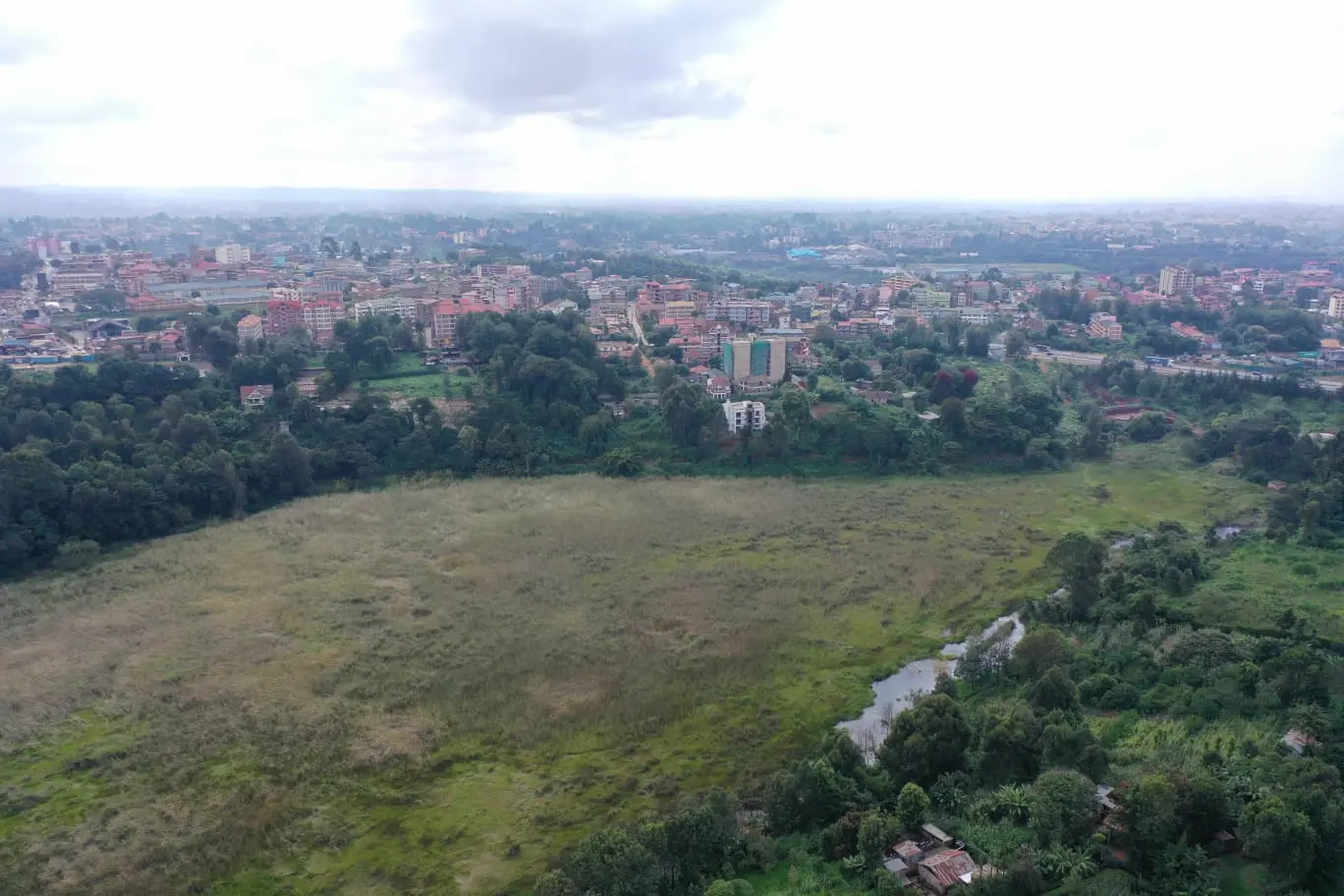
Ondiri wetland is located 200m South of Kikuyu town in Kikuyu ward, Kikuyu Sub-County in Kiambu County and 20km West of Nairobi City.
The wetland ecosystem is surrounded by 6 administrative locations: Kikuyu, Muguga, Sigona, Karai, Kinoo and Kabete. It lies at longitude 36.657186 and latitude -1.248375 at an altitude of 2000m above sea level.
Key Geographical Details
- Size 34.5 hectares
- Perimeter 3.3km
- Depth 2-3 meters
- Altitude 2000m ASL
- Status Kenya's largest peat bog
- Coordinates 36.657186, -1.248375
Nyongara River has its direct source from Ondiri wetland and forms the main tributary of Nairobi River. The wetland recharges the Kikuyu springs through a subterranean passage, the oldest source of piped water for Nairobi city.
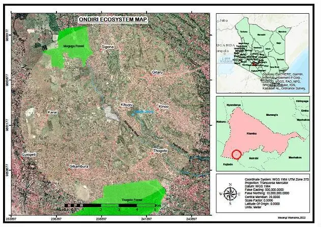
Ondiri Wetland surrounded by 6 administrative locations
Water Systems
Hydrological Importance
Water Source
Direct source of Nyongara River, main tributary of Nairobi River which flows into Athi River and finally the Indian Ocean.
Recharge System
Recharges Kikuyu Springs through subterranean passage and receives water from three streams from Muguga Forest.
Underground Streams
Source of three underground streams: Mbagathi, Kabuthi and Rungiri, which resurface near Karen Estate.
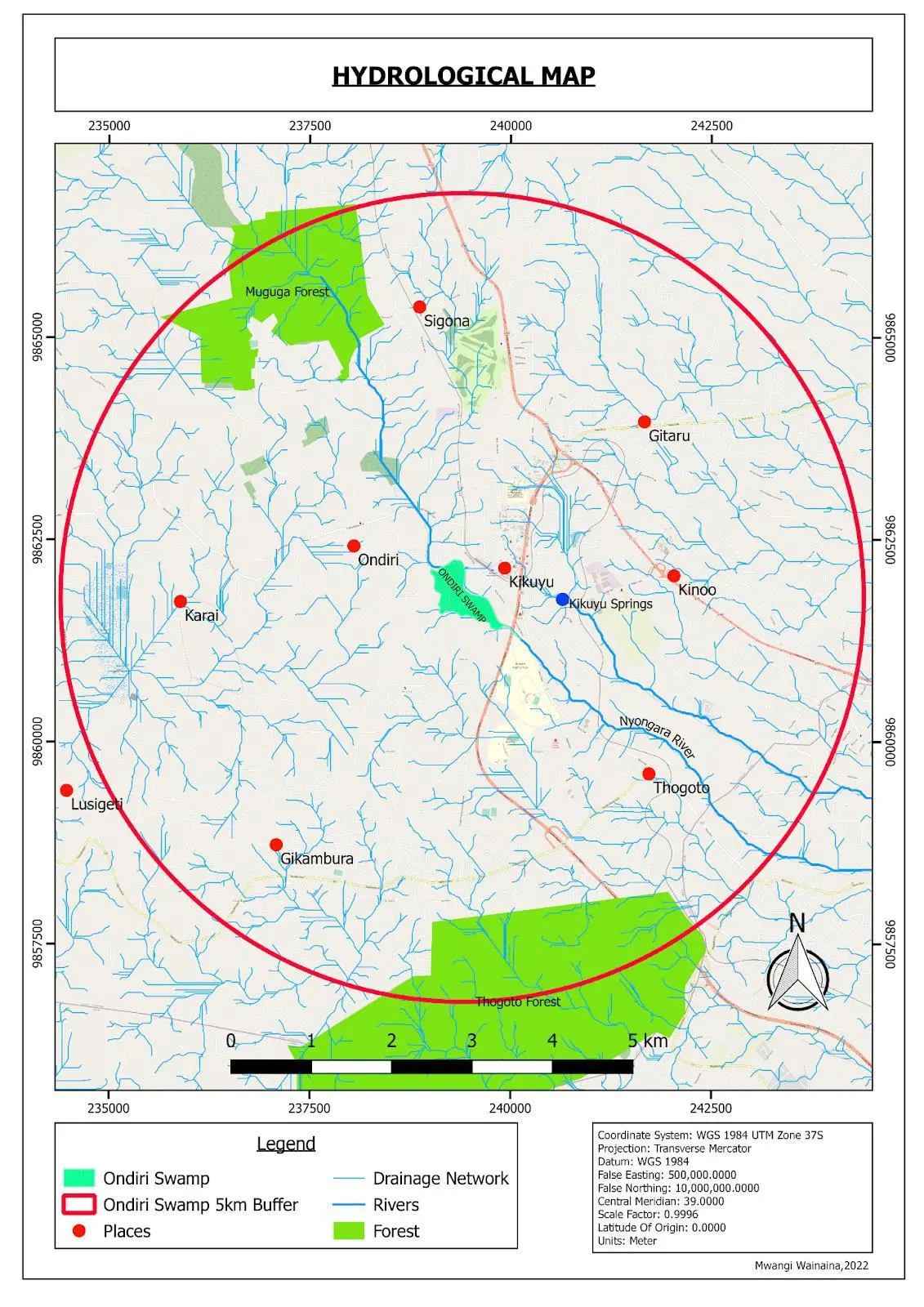
The wetland is part of the Lari-Ondiri fault drainage system and is believed to have an underground source, making it perennial despite seasonal variations.
People & Place
Demography & Human Influence
The area around the swamp has a fast growing population as a result of urban influence of nearby Kikuyu town that is characterized by high in-migration.
Population Density
1,186 persons/km²
In Kikuyu location surrounding the wetland
Karai Location
1,068 persons/km²
Borders the swamp to the South
Although the surrounding area is cosmopolitan, it is dominated by Kikuyu ethnic groups. The swamp has attracted various user groups including:
- Friends of Ondiri Wetland Kenya (FOWK)
- Water Resource User Association (WRUA)
- Farmers for irrigation
- Schools & Institutions
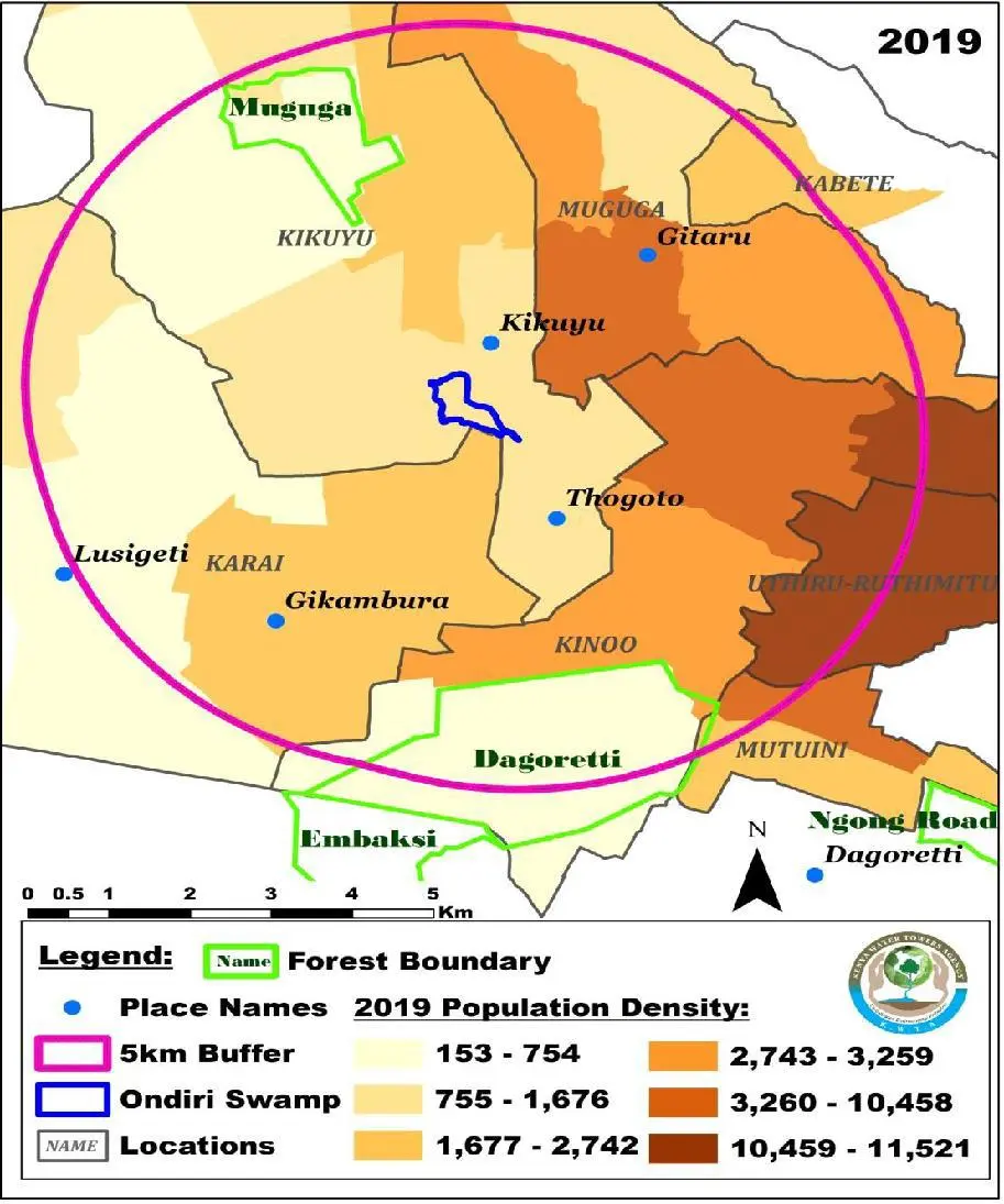
Population density around Ondiri Swamp as at 2019
-
Annual Rainfall 1500 mm
-
Mean Temperature 26°C (range: 20.4-34°C)
-
Rain Seasons Long: Mar-May
Short: Oct-Nov -
Topography Foot of Kikuyu escarpment
Landscape
Physical Characteristics
Geology & Soils
The geology comprises faulted north–south oriented late quaternary lava flows and pyroclastic of trachytic composition from the Kenyan Rift Valley formation.
Soils consist of well-drained podsols and andesols, extremely deep, grey/red to dark brown friable clays. Some areas have imperfectly drained dark to black soils in valley bottoms.
Soil fertility: Moderate, supporting crops like cabbages, tomatoes, spinach, kales and carrots.
Climate
Bi-modal rainfall pattern:
- Long rains: Mid-March to May
- Cold season: June to August (drizzles & frost)
- Short rains: Mid-October to November
Temperature extremes: Hottest in Jan-Feb, coldest in July-August. Ranges from 20.4°C in highlands to 34°C in Karai midlands.
Topography
Located at the foot of Kikuyu escarpment surrounded by hilly landscape. Kikuyu town lies on the raised northern side. The area slopes gently eastwards from 2000m ASL to around 1600m in Nairobi city.
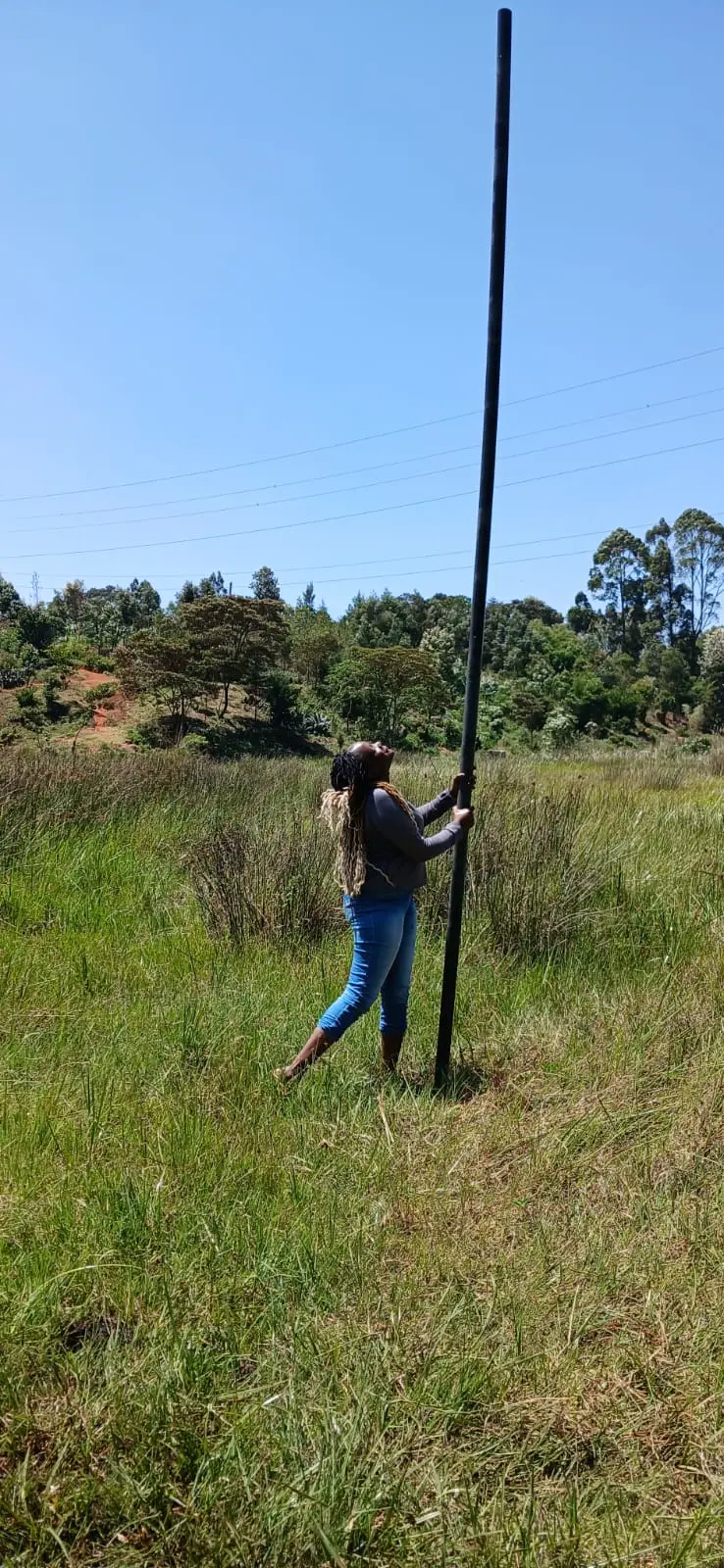
Did You Know
The entire length of this pipe disappears straight into the bog!
Did you know that Ondiri Wetland is the second deepest peat bog in Africa, only after the one in Douala, Cameroon? And did you also know that Ondiri Wetland (just outside Kikuyu town) is the ONLY high-altitude peat bog in Kenya?
This rare ecosystem is a national treasure and a vital water recharge zone that deserves all our protection.
Life In The Wetland
Biodiversity
Flora
68 plant species (aquatic and semi-aquatic) recorded.
Common species: Typha domingensis, Vossia cuspidate, Cyperus brevifolius, Leersia hexandra, Eragrostis exasperate, Eriochloa meyerana.
Plants grow on accumulated semi-decomposed organic matter forming 0.5m thick peat layer on water surface.
Indigenous Trees (Catchment area)
- Warburgia ugandensis
- Prunus africana
- Podocarpus milanjianus
- Acacia melanoxylon
- Ocotea usambarensis
- Croton megalocarpus
- Brachylaena huillensis
- Diospyros abyssinica
Exotic Trees
Grevillea robusta, Eucalyptus spp., Jacaranda mimosifolia, Cupressus lusitanica.
Note: Several diatom species (algae) recorded, useful as indicators of nutrient concentration (phosphate & nitrogen).
Fauna
94 species of resident and migratory birds recorded.
Notable Bird Species
- Cattle Egret
- Sacred Ibis
- Hadada Ibis
- Kingfishers
- Hammer kop
- Jackson's widow
- Grey crowned cranes (endangered)
- African marsh harrier
- Marabou stork (rare visitor)
Critical function: Provides crucial breeding sites for birds and adequate food during breeding and migration.
Other Fauna
- Insects & Crustaceans: Dominated by pollution-insensitive beetle families (Dytiscidae – diving beetles, Hydrophilidae – water scavenger beetles)
- Amphibians: Various species providing food for birds
- Small Carnivores: Mongooses and wildcats in tall grass
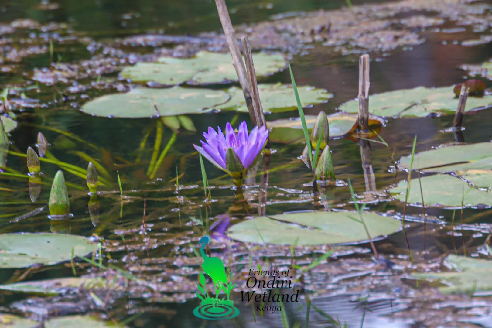
Aquatic vegetation
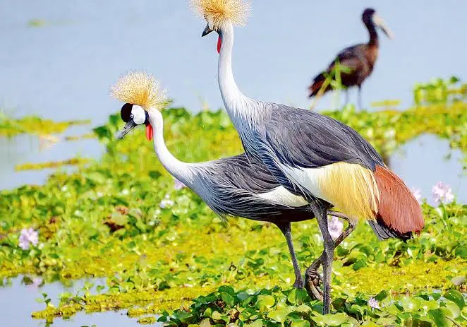
Bird species including the endangered Grey Crowned Crane
The unique quaking bog characteristic
The Story So Far
Historical Context & Conservation Status
Origin & Characteristics
Formerly known as “Kahenia” (meaning “shiny surface”), Ondiri was once an open lake that glittered in the sunlight. The name 'Ondiri' is alleged to be a Gikuyu corruption of 'old lake' (Undiri). It is a unique Palustrine wetland (marshes, swamps and peat bogs).
Unique feature: When walked upon, the whole bog quakes like a bouncing castle due to the floating reed-mat on peat.
The swamp is oval in shape and allegedly used to be an open lake in the early 19th century. Over years, deforestation and erosion led to coverage by floating reeds on peat, creating a quaking bog - the largest in Kenya.
Scientific Perspective
A 2011 groundwater recharge study disputed the 'drying up' theory, indicating water level remains unchanged as long as recharge-discharge relationship remains constant. Any apparent drying is more likely due to eutrophication rather than reduced groundwater.
Conservation Alert
No Legal Protection
Ondiri swamp is not under any form of legal protection, as is the case with most small wetland ecosystems in Kenya.
Minimal Government Attention
Despite Kenya being party to the Ramsar Convention since 1990 (which obligates sustainable wetland management), Ondiri has received minimal attention from both National and County Governments.
Historical Exploitation
Like other wetlands, Ondiri was regarded as a common resource with no exploitation restrictions, threatening its existence. Ecosystem destruction dates to colonial era with extensive deforestation for settlement and development.
Call to Action
Ondiri Wetland requires immediate conservation measures, legal protection, and sustainable management to preserve its critical ecological functions, biodiversity, and water supply for current and future generations.
The Numbers
Ondiri Wetland at a Glance
Hectares Size
Plant Species
Bird Species
KM Perimeter
Sources & References
- Ondiri-Wetland-IMP-2022-2027
- Macharia et al. (2010)
- Kenya National Bureau of Statistics (2019)
- Onkaru WRUA (2013)
- NECC (2018)
- County Government of Kiambu (2018)